


Kiko’s Farewell: Hawaii Braces for Swells, But Dodges the Direct Hit
Kiko’s Passage: A Near Miss for Hawaii
Hurricane Kiko, a storm that initially reached Category 4 strength, is now charting a course that will likely spare the Hawaiian Islands from a direct landfall. While the threat of destructive winds and torrential rain has diminished significantly, residents and visitors alike are urged to remain vigilant as Kiko’s impact will still be felt across the Big Island and Maui.
From Fury to Fade: Tracking Kiko’s Path
The latest forecasts place Hurricane Kiko tracking north of the Hawaiian Islands. This shift in trajectory has been a welcome development, significantly reducing the probability of a direct hit and the associated risks of widespread damage. The National Weather Service has been closely monitoring the storm’s progress, providing updates and guidance to local authorities. Despite the decreased wind threat, the effects of Kiko are still expected to be significant.
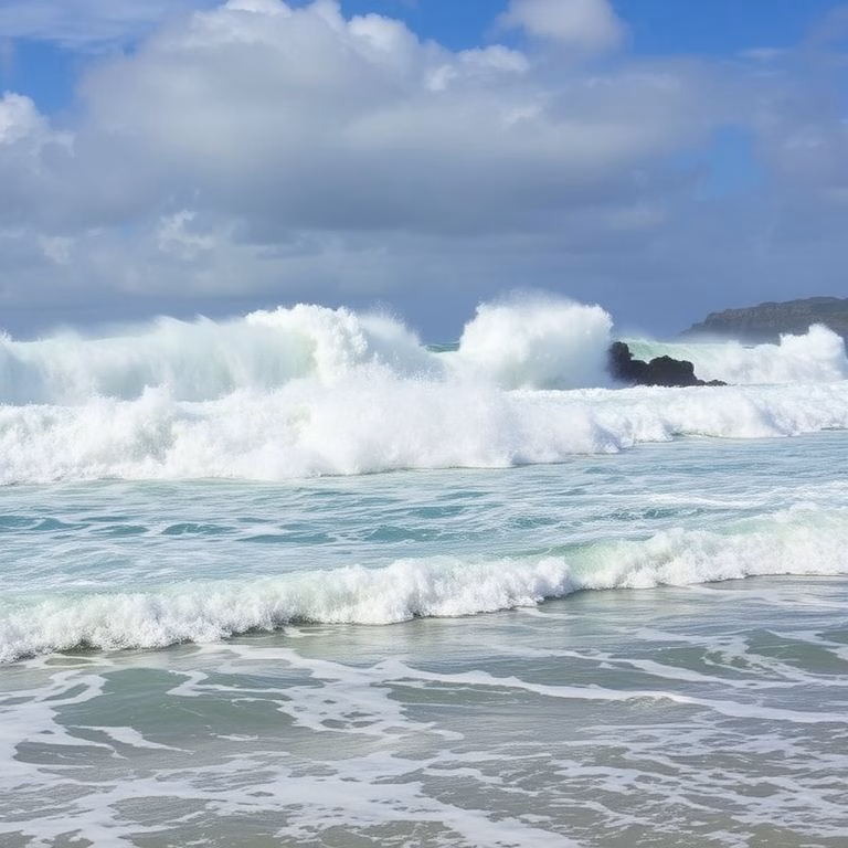
Swells and Surges: The Ocean’s Warning
Even though the core of the storm is moving away, the ocean will still bear the brunt of Kiko’s power. Starting Sunday, residents and visitors on the Big Island and Maui should brace themselves for the arrival of large swells. These swells have the potential to generate dangerous and potentially life-threatening rip currents along the coast. The peak impact is expected late Monday through the middle of the week. Lifeguards and officials are urging caution and advising people to avoid swimming in areas with hazardous surf conditions during this period.
State of Emergency Declared
Governor of Hawaii, in anticipation of Kiko’s potential impact, declared a state of emergency. This action allows state agencies to mobilize resources and personnel quickly and effectively. The declaration provides the state with the flexibility to respond to any eventualities, including assisting local communities with preparedness efforts. It’s a proactive measure taken to ensure the safety and well-being of all residents.
Weakening Trend: Tropical Storm Status Anticipated
A positive aspect of Kiko’s journey is the forecasted weakening trend. Meteorologists predict that the hurricane will lose intensity and likely transition into a tropical storm by Tuesday. This weakening, coupled with the storm’s northerly track, further minimizes the risk of a direct impact on the islands. The projected path indicates Kiko will continue to pass north of the Hawaiian chain, avoiding a direct landfall.
Probability of Landfall: Very Low
The current consensus among weather models indicates a very low probability of a direct landfall. While this is reassuring, authorities emphasize that everyone should remain prepared and informed. The situation can evolve quickly, and staying updated with official advisories is crucial. The Pacific Disaster Center is constantly providing updates. Local authorities, including those on the Big Island and Maui, will continue to monitor the situation.
Staying Safe During the Storm
While the direct threat of Hurricane Kiko is lessening, the public is urged to take necessary precautions. This includes staying informed about weather updates, securing loose outdoor items, and following the instructions of local authorities. Even as the storm moves further away, the risk of hazardous conditions from swells and rip currents remains. Planning ahead and staying informed will ensure everyone stays safe during Kiko’s departure.
This situation shows the importance of preparedness and cooperation between state and local agencies. It also highlights the unpredictable nature of weather events. While dodging a direct hit is favorable news for the Hawaiian islands, residents are encouraged to stay vigilant and informed.
For further reading and the latest updates, please consult the following sources:
https://www.cnn.com/2025/09/06/us/hurricane-kiko-hawaii
https://www.newsweek.com/hurricane-kiko-update-path-system-moves-towards-hawaii-2125925
https://www.foxweather.com/weather-news/hurricane-kiko-hawaii-state-of-emergency